pacman::p_load(sf, sfdep, tmap, tidyverse)In-Class Exercise 6: Spatial Weights & Applications
Imports
Import Packages
Import Data
Geospatial
hunan <- st_read(dsn = "data/geospatial",
                 layer = "Hunan")
Reading layer `Hunan' from data source
`/Users/michelle/Desktop/IS415/shelle-mim/IS415-GAA/In-class_Exercise/Wk6/data/geospatial'
using driver `ESRI Shapefile'
Simple feature collection with 88 features and 7 fields
Geometry type: POLYGON
Dimension: XY
Bounding box: xmin: 108.7831 ymin: 24.6342 xmax: 114.2544 ymax: 30.12812
Geodetic CRS: WGS 84Aspatial
hunan2012 <- read_csv("data/aspatial/Hunan_2012.csv")Join Data
# Left relational join
hunan_GDPPC <- left_join(hunan, hunan2012)%>%
  select(1:4, 7, 15)
Exploring the data
Choropleth Map
tm_shape(hunan_GDPPC)+
  tm_fill("GDPPC",
          style = "quantile",
          palette = "RdPu",
          title = "Dependency ratio") +
  tm_layout(main.title = "Distribution of GDP per capita by district, Hunan Province",
            main.title.position = "center",
            main.title.size = 1,
            legend.outside = TRUE,
            frame = TRUE) +
  tm_borders(alpha = 0.5) +
  tm_grid(alpha =0.2) +
  tm_compass(type="8star", size = 2) +
  tm_scale_bar()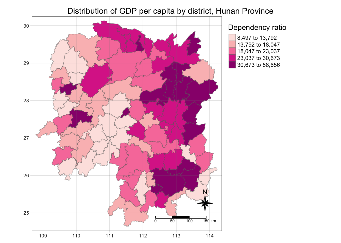
Identify Area Neighbours
Contiguity Neighbours Method (Adjacency Method)
# Using queen's method
cn_queen <- hunan_GDPPC %>%
  mutate(nb = st_contiguity(geometry),
         .before = 1) # puts newly created field as first col
# Using rook's method
cn_rook <- hunan_GDPPC %>%
mutate(nb = st_contiguity(geometry), queen = FALSE, .before = 1)nb_queen <- hunan_GDPPC %>%
mutate(nb = st_contiguity(geometry),
.before = 1)# Print summary 9of first lag neighbour
summary(nb_queen$nb)Neighbour list object:
Number of regions: 88
Number of nonzero links: 448
Percentage nonzero weights: 5.785124
Average number of links: 5.090909
Link number distribution:
1 2 3 4 5 6 7 8 9 11
2 2 12 16 24 14 11 4 2 1
2 least connected regions:
30 65 with 1 link
1 most connected region:
85 with 11 links# View content of data tbale
nb_queenSimple feature collection with 88 features and 7 fields
Geometry type: POLYGON
Dimension: XY
Bounding box: xmin: 108.7831 ymin: 24.6342 xmax: 114.2544 ymax: 30.12812
Geodetic CRS: WGS 84
First 10 features:
nb NAME_2 ID_3 NAME_3 ENGTYPE_3
1 2, 3, 4, 57, 85 Changde 21098 Anxiang County
2 1, 57, 58, 78, 85 Changde 21100 Hanshou County
3 1, 4, 5, 85 Changde 21101 Jinshi County City
4 1, 3, 5, 6 Changde 21102 Li County
5 3, 4, 6, 85 Changde 21103 Linli County
6 4, 5, 69, 75, 85 Changde 21104 Shimen County
7 67, 71, 74, 84 Changsha 21109 Liuyang County City
8 9, 46, 47, 56, 78, 80, 86 Changsha 21110 Ningxiang County
9 8, 66, 68, 78, 84, 86 Changsha 21111 Wangcheng County
10 16, 17, 19, 20, 22, 70, 72, 73 Chenzhou 21112 Anren County
County GDPPC geometry
1 Anxiang 23667 POLYGON ((112.0625 29.75523...
2 Hanshou 20981 POLYGON ((112.2288 29.11684...
3 Jinshi 34592 POLYGON ((111.8927 29.6013,...
4 Li 24473 POLYGON ((111.3731 29.94649...
5 Linli 25554 POLYGON ((111.6324 29.76288...
6 Shimen 27137 POLYGON ((110.8825 30.11675...
7 Liuyang 63118 POLYGON ((113.9905 28.5682,...
8 Ningxiang 62202 POLYGON ((112.7181 28.38299...
9 Wangcheng 70666 POLYGON ((112.7914 28.52688...
10 Anren 12761 POLYGON ((113.1757 26.82734...# Reveal county name of neighbours
nb_queen$County[c(2,3,4,57,85)][1] "Hanshou" "Jinshi" "Li" "Nan" "Taoyuan"Identify higher order neighbours
# Get both 1st and 2nd order neighbours
nb2_queen <-  hunan_GDPPC %>%
  mutate(nb = st_contiguity(geometry),
         nb2 = st_nb_lag_cumul(nb, 2),
.before = 1)nb2_queenSimple feature collection with 88 features and 8 fields
Geometry type: POLYGON
Dimension: XY
Bounding box: xmin: 108.7831 ymin: 24.6342 xmax: 114.2544 ymax: 30.12812
Geodetic CRS: WGS 84
First 10 features:
nb
1 2, 3, 4, 57, 85
2 1, 57, 58, 78, 85
3 1, 4, 5, 85
4 1, 3, 5, 6
5 3, 4, 6, 85
6 4, 5, 69, 75, 85
7 67, 71, 74, 84
8 9, 46, 47, 56, 78, 80, 86
9 8, 66, 68, 78, 84, 86
10 16, 17, 19, 20, 22, 70, 72, 73
nb2
1 2, 3, 4, 5, 6, 32, 56, 57, 58, 64, 69, 75, 76, 78, 85
2 1, 3, 4, 5, 6, 8, 9, 32, 56, 57, 58, 64, 68, 69, 75, 76, 78, 85
3 1, 2, 4, 5, 6, 32, 56, 57, 69, 75, 78, 85
4 1, 2, 3, 5, 6, 57, 69, 75, 85
5 1, 2, 3, 4, 6, 32, 56, 57, 69, 75, 78, 85
6 1, 2, 3, 4, 5, 32, 53, 55, 56, 57, 69, 75, 78, 85
7 9, 19, 66, 67, 71, 73, 74, 76, 84, 86
8 2, 9, 19, 21, 31, 32, 34, 35, 36, 41, 45, 46, 47, 56, 58, 66, 68, 74, 78, 80, 84, 85, 86
9 2, 7, 8, 19, 21, 35, 46, 47, 56, 58, 66, 67, 68, 74, 76, 78, 80, 84, 85, 86
10 11, 14, 15, 16, 17, 18, 19, 20, 21, 22, 23, 70, 71, 72, 73, 74, 82, 83, 86
NAME_2 ID_3 NAME_3 ENGTYPE_3 County GDPPC
1 Changde 21098 Anxiang County Anxiang 23667
2 Changde 21100 Hanshou County Hanshou 20981
3 Changde 21101 Jinshi County City Jinshi 34592
4 Changde 21102 Li County Li 24473
5 Changde 21103 Linli County Linli 25554
6 Changde 21104 Shimen County Shimen 27137
7 Changsha 21109 Liuyang County City Liuyang 63118
8 Changsha 21110 Ningxiang County Ningxiang 62202
9 Changsha 21111 Wangcheng County Wangcheng 70666
10 Chenzhou 21112 Anren County Anren 12761
geometry
1 POLYGON ((112.0625 29.75523...
2 POLYGON ((112.2288 29.11684...
3 POLYGON ((111.8927 29.6013,...
4 POLYGON ((111.3731 29.94649...
5 POLYGON ((111.6324 29.76288...
6 POLYGON ((110.8825 30.11675...
7 POLYGON ((113.9905 28.5682,...
8 POLYGON ((112.7181 28.38299...
9 POLYGON ((112.7914 28.52688...
10 POLYGON ((113.1757 26.82734...Deriving contiguity weights
Queen’s Method
# Derive weights
wm_q <- hunan_GDPPC %>%
  mutate(nb = st_contiguity(geometry),
         wt = st_weights(nb,
                         style = "W"),
         .before = 1)

wm_q
Simple feature collection with 88 features and 8 fields
Geometry type: POLYGON
Dimension: XY
Bounding box: xmin: 108.7831 ymin: 24.6342 xmax: 114.2544 ymax: 30.12812
Geodetic CRS: WGS 84
First 10 features:
nb
1 2, 3, 4, 57, 85
2 1, 57, 58, 78, 85
3 1, 4, 5, 85
4 1, 3, 5, 6
5 3, 4, 6, 85
6 4, 5, 69, 75, 85
7 67, 71, 74, 84
8 9, 46, 47, 56, 78, 80, 86
9 8, 66, 68, 78, 84, 86
10 16, 17, 19, 20, 22, 70, 72, 73
wt
1 0.2, 0.2, 0.2, 0.2, 0.2
2 0.2, 0.2, 0.2, 0.2, 0.2
3 0.25, 0.25, 0.25, 0.25
4 0.25, 0.25, 0.25, 0.25
5 0.25, 0.25, 0.25, 0.25
6 0.2, 0.2, 0.2, 0.2, 0.2
7 0.25, 0.25, 0.25, 0.25
8 0.1428571, 0.1428571, 0.1428571, 0.1428571, 0.1428571, 0.1428571, 0.1428571
9 0.1666667, 0.1666667, 0.1666667, 0.1666667, 0.1666667, 0.1666667
10 0.125, 0.125, 0.125, 0.125, 0.125, 0.125, 0.125, 0.125
NAME_2 ID_3 NAME_3 ENGTYPE_3 County GDPPC
1 Changde 21098 Anxiang County Anxiang 23667
2 Changde 21100 Hanshou County Hanshou 20981
3 Changde 21101 Jinshi County City Jinshi 34592
4 Changde 21102 Li County Li 24473
5 Changde 21103 Linli County Linli 25554
6 Changde 21104 Shimen County Shimen 27137
7 Changsha 21109 Liuyang County City Liuyang 63118
8 Changsha 21110 Ningxiang County Ningxiang 62202
9 Changsha 21111 Wangcheng County Wangcheng 70666
10 Chenzhou 21112 Anren County Anren 12761
geometry
1 POLYGON ((112.0625 29.75523...
2 POLYGON ((112.2288 29.11684...
3 POLYGON ((111.8927 29.6013,...
4 POLYGON ((111.3731 29.94649...
5 POLYGON ((111.6324 29.76288...
6 POLYGON ((110.8825 30.11675...
7 POLYGON ((113.9905 28.5682,...
8 POLYGON ((112.7181 28.38299...
9 POLYGON ((112.7914 28.52688...
10 POLYGON ((113.1757 26.82734...Rook’s Method
wm_r <- hunan %>%
  mutate(nb = st_contiguity(geometry,
                            queen = FALSE),
         wt = st_weights(nb),
         .before = 1)

wm_r
Simple feature collection with 88 features and 9 fields
Geometry type: POLYGON
Dimension: XY
Bounding box: xmin: 108.7831 ymin: 24.6342 xmax: 114.2544 ymax: 30.12812
Geodetic CRS: WGS 84
First 10 features:
nb
1 3, 4, 57, 85
2 57, 58, 78, 85
3 1, 4, 5, 85
4 1, 3, 5, 6
5 3, 4, 6, 85
6 4, 5, 69, 75, 85
7 67, 71, 74, 84
8 9, 46, 47, 56, 78, 80, 86
9 8, 66, 68, 78, 84, 86
10 16, 19, 20, 22, 70, 72, 73
wt
1 0.25, 0.25, 0.25, 0.25
2 0.25, 0.25, 0.25, 0.25
3 0.25, 0.25, 0.25, 0.25
4 0.25, 0.25, 0.25, 0.25
5 0.25, 0.25, 0.25, 0.25
6 0.2, 0.2, 0.2, 0.2, 0.2
7 0.25, 0.25, 0.25, 0.25
8 0.1428571, 0.1428571, 0.1428571, 0.1428571, 0.1428571, 0.1428571, 0.1428571
9 0.1666667, 0.1666667, 0.1666667, 0.1666667, 0.1666667, 0.1666667
10 0.1428571, 0.1428571, 0.1428571, 0.1428571, 0.1428571, 0.1428571, 0.1428571
NAME_2 ID_3 NAME_3 ENGTYPE_3 Shape_Leng Shape_Area County
1 Changde 21098 Anxiang County 1.869074 0.10056190 Anxiang
2 Changde 21100 Hanshou County 2.360691 0.19978745 Hanshou
3 Changde 21101 Jinshi County City 1.425620 0.05302413 Jinshi
4 Changde 21102 Li County 3.474325 0.18908121 Li
5 Changde 21103 Linli County 2.289506 0.11450357 Linli
6 Changde 21104 Shimen County 4.171918 0.37194707 Shimen
7 Changsha 21109 Liuyang County City 4.060579 0.46016789 Liuyang
8 Changsha 21110 Ningxiang County 3.323754 0.26614198 Ningxiang
9 Changsha 21111 Wangcheng County 2.292093 0.13049161 Wangcheng
10 Chenzhou 21112 Anren County 2.240739 0.13343936 Anren
geometry
1 POLYGON ((112.0625 29.75523...
2 POLYGON ((112.2288 29.11684...
3 POLYGON ((111.8927 29.6013,...
4 POLYGON ((111.3731 29.94649...
5 POLYGON ((111.6324 29.76288...
6 POLYGON ((110.8825 30.11675...
7 POLYGON ((113.9905 28.5682,...
8 POLYGON ((112.7181 28.38299...
9 POLYGON ((112.7914 28.52688...
10 POLYGON ((113.1757 26.82734...Distance-Based Weights
Types of distance-based spatial weights:
fixed distance weights,
adaptive distance weights, and
inverse distance weights (IDW).
Fixed Weights
# Determine upper limit for dist band
geo <- sf::st_geometry(hunan_GDPPC)
nb <- st_knn(geo, longlat = TRUE)
dists <- unlist(st_nb_dists(geo, nb))

summary(dists)
Min. 1st Qu. Median Mean 3rd Qu. Max.
21.56 29.11 36.89 37.34 43.21 65.80 # Computed dixed weights
wm_fd <- hunan_GDPPC %>%
mutate(nb = st_dist_band(geometry,
upper = 66),
wt = st_weights(nb),
.before = 1)
wm_fdSimple feature collection with 88 features and 8 fields
Geometry type: POLYGON
Dimension: XY
Bounding box: xmin: 108.7831 ymin: 24.6342 xmax: 114.2544 ymax: 30.12812
Geodetic CRS: WGS 84
First 10 features:
nb
1 2, 3, 4, 5, 57, 64
2 1, 57, 58, 78, 85
3 1, 4, 5, 57
4 1, 3, 5, 6
5 1, 3, 4, 6, 69
6 4, 5, 69
7 67, 71, 84
8 9, 46, 47, 78, 80
9 8, 46, 66, 68, 84, 86
10 16, 20, 22, 70, 72, 73
wt NAME_2
1 0.1666667, 0.1666667, 0.1666667, 0.1666667, 0.1666667, 0.1666667 Changde
2 0.2, 0.2, 0.2, 0.2, 0.2 Changde
3 0.25, 0.25, 0.25, 0.25 Changde
4 0.25, 0.25, 0.25, 0.25 Changde
5 0.2, 0.2, 0.2, 0.2, 0.2 Changde
6 0.3333333, 0.3333333, 0.3333333 Changde
7 0.3333333, 0.3333333, 0.3333333 Changsha
8 0.2, 0.2, 0.2, 0.2, 0.2 Changsha
9 0.1666667, 0.1666667, 0.1666667, 0.1666667, 0.1666667, 0.1666667 Changsha
10 0.1666667, 0.1666667, 0.1666667, 0.1666667, 0.1666667, 0.1666667 Chenzhou
ID_3 NAME_3 ENGTYPE_3 County GDPPC geometry
1 21098 Anxiang County Anxiang 23667 POLYGON ((112.0625 29.75523...
2 21100 Hanshou County Hanshou 20981 POLYGON ((112.2288 29.11684...
3 21101 Jinshi County City Jinshi 34592 POLYGON ((111.8927 29.6013,...
4 21102 Li County Li 24473 POLYGON ((111.3731 29.94649...
5 21103 Linli County Linli 25554 POLYGON ((111.6324 29.76288...
6 21104 Shimen County Shimen 27137 POLYGON ((110.8825 30.11675...
7 21109 Liuyang County City Liuyang 63118 POLYGON ((113.9905 28.5682,...
8 21110 Ningxiang County Ningxiang 62202 POLYGON ((112.7181 28.38299...
9 21111 Wangcheng County Wangcheng 70666 POLYGON ((112.7914 28.52688...
10 21112 Anren County Anren 12761 POLYGON ((113.1757 26.82734...Adaptive Distance Weights
wm_ad <- hunan_GDPPC %>%
  mutate(nb = st_knn(geometry,
                     k=8),
         wt = st_weights(nb),
               .before = 1)

wm_ad
Simple feature collection with 88 features and 8 fields
Geometry type: POLYGON
Dimension: XY
Bounding box: xmin: 108.7831 ymin: 24.6342 xmax: 114.2544 ymax: 30.12812
Geodetic CRS: WGS 84
First 10 features:
nb
1 2, 3, 4, 5, 57, 58, 64, 76
2 1, 3, 8, 57, 58, 68, 78, 85
3 1, 2, 4, 5, 6, 57, 64, 85
4 1, 2, 3, 5, 6, 57, 64, 69
5 1, 2, 3, 4, 6, 57, 69, 85
6 1, 2, 3, 4, 5, 69, 75, 85
7 9, 66, 67, 68, 71, 74, 84, 86
8 2, 9, 35, 46, 47, 78, 80, 86
9 8, 46, 47, 66, 68, 78, 84, 86
10 16, 17, 19, 20, 22, 70, 72, 73
wt NAME_2 ID_3
1 0.125, 0.125, 0.125, 0.125, 0.125, 0.125, 0.125, 0.125 Changde 21098
2 0.125, 0.125, 0.125, 0.125, 0.125, 0.125, 0.125, 0.125 Changde 21100
3 0.125, 0.125, 0.125, 0.125, 0.125, 0.125, 0.125, 0.125 Changde 21101
4 0.125, 0.125, 0.125, 0.125, 0.125, 0.125, 0.125, 0.125 Changde 21102
5 0.125, 0.125, 0.125, 0.125, 0.125, 0.125, 0.125, 0.125 Changde 21103
6 0.125, 0.125, 0.125, 0.125, 0.125, 0.125, 0.125, 0.125 Changde 21104
7 0.125, 0.125, 0.125, 0.125, 0.125, 0.125, 0.125, 0.125 Changsha 21109
8 0.125, 0.125, 0.125, 0.125, 0.125, 0.125, 0.125, 0.125 Changsha 21110
9 0.125, 0.125, 0.125, 0.125, 0.125, 0.125, 0.125, 0.125 Changsha 21111
10 0.125, 0.125, 0.125, 0.125, 0.125, 0.125, 0.125, 0.125 Chenzhou 21112
NAME_3 ENGTYPE_3 County GDPPC geometry
1 Anxiang County Anxiang 23667 POLYGON ((112.0625 29.75523...
2 Hanshou County Hanshou 20981 POLYGON ((112.2288 29.11684...
3 Jinshi County City Jinshi 34592 POLYGON ((111.8927 29.6013,...
4 Li County Li 24473 POLYGON ((111.3731 29.94649...
5 Linli County Linli 25554 POLYGON ((111.6324 29.76288...
6 Shimen County Shimen 27137 POLYGON ((110.8825 30.11675...
7 Liuyang County City Liuyang 63118 POLYGON ((113.9905 28.5682,...
8 Ningxiang County Ningxiang 62202 POLYGON ((112.7181 28.38299...
9 Wangcheng County Wangcheng 70666 POLYGON ((112.7914 28.52688...
10 Anren County Anren 12761 POLYGON ((113.1757 26.82734...Inverse Distance Weights
wm_idw <- hunan_GDPPC %>%
  mutate(nb = st_contiguity(geometry),
         wts = st_inverse_distance(nb, geometry,
                                   scale = 1,
                                   alpha = 1),
         .before = 1)

wm_idw
Simple feature collection with 88 features and 8 fields
Geometry type: POLYGON
Dimension: XY
Bounding box: xmin: 108.7831 ymin: 24.6342 xmax: 114.2544 ymax: 30.12812
Geodetic CRS: WGS 84
First 10 features:
nb
1 2, 3, 4, 57, 85
2 1, 57, 58, 78, 85
3 1, 4, 5, 85
4 1, 3, 5, 6
5 3, 4, 6, 85
6 4, 5, 69, 75, 85
7 67, 71, 74, 84
8 9, 46, 47, 56, 78, 80, 86
9 8, 66, 68, 78, 84, 86
10 16, 17, 19, 20, 22, 70, 72, 73
wts
1 0.01526149, 0.03515537, 0.02176677, 0.02836978, 0.01029857
2 0.01526149, 0.01601100, 0.01911052, 0.02327058, 0.01591694
3 0.03515537, 0.04581089, 0.04116397, 0.01208437
4 0.02176677, 0.04581089, 0.04637578, 0.01585302
5 0.04116397, 0.04637578, 0.01896212, 0.01351099
6 0.01585302, 0.01896212, 0.02710909, 0.01140718, 0.01080890
7 0.01621067, 0.01536702, 0.01133628, 0.01836488
8 0.01930410, 0.02675555, 0.02151751, 0.01076895, 0.02608065, 0.01519804, 0.01337412
9 0.01930410, 0.01651371, 0.01798519, 0.01473155, 0.03015561, 0.01612293
10 0.02737233, 0.01390810, 0.01458881, 0.02156771, 0.02419268, 0.02350470, 0.01784174, 0.01621545
NAME_2 ID_3 NAME_3 ENGTYPE_3 County GDPPC
1 Changde 21098 Anxiang County Anxiang 23667
2 Changde 21100 Hanshou County Hanshou 20981
3 Changde 21101 Jinshi County City Jinshi 34592
4 Changde 21102 Li County Li 24473
5 Changde 21103 Linli County Linli 25554
6 Changde 21104 Shimen County Shimen 27137
7 Changsha 21109 Liuyang County City Liuyang 63118
8 Changsha 21110 Ningxiang County Ningxiang 62202
9 Changsha 21111 Wangcheng County Wangcheng 70666
10 Chenzhou 21112 Anren County Anren 12761
geometry
1 POLYGON ((112.0625 29.75523...
2 POLYGON ((112.2288 29.11684...
3 POLYGON ((111.8927 29.6013,...
4 POLYGON ((111.3731 29.94649...
5 POLYGON ((111.6324 29.76288...
6 POLYGON ((110.8825 30.11675...
7 POLYGON ((113.9905 28.5682,...
8 POLYGON ((112.7181 28.38299...
9 POLYGON ((112.7914 28.52688...
10 POLYGON ((113.1757 26.82734...